

CAD Mapper is free for any area up to 1 km², and free without an account for whole-city road networks in 241 metro areas. Beyond 1 km² it charges a small fee, with a discount on academic email addresses. Files arrive as a zipped, layered CAD drawing in meters — usually within a couple of minutes of drawing your boundary.
That one paragraph is the answer most people arrive looking for. The rest of this guide covers what the free tier actually contains, the export format to pick for your software, the licensing position on commercial work, and the handful of quirks that make people think the download is empty when it isn’t.
Pricing, limits and format support on this page were checked against cadmapper.com and its official documentation in August 2026. CAD Mapper changes its tiers occasionally — the live site is always the final word.
What is CAD Mapper?
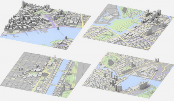
CAD Mapper is a web tool that converts public geographic data into ready-to-use CAD files. You draw a rectangle over any location on earth, choose a format, and it returns a layered drawing containing roads, building footprints, water bodies and — in many locations — building heights and terrain.
The underlying data comes from OpenStreetMap, NASA and USGS. The service is operated by Protomaps LLC, and the CAD files it produces are distributed under the Open Database License.
The practical value is straightforward: producing a site base drawing by hand, or by tracing an aerial image, is hours of work that adds nothing to a design. CAD Mapper compresses that into a few minutes. The drawing still needs your judgement — but not your tracing.
Is CAD Mapper free? The limits, stated plainly
Yes, with two distinct free routes and one paid one. This is the part the official homepage compresses into three tiles, and it is where most of the confusion starts.
| Tier | Area covered | Account needed? | Cost | What you get |
|---|---|---|---|---|
| Whole City Files | Entire metro area | No | Free | Large simplified 2D DXF: road networks in three levels as polylines, plus bodies of water. No buildings, no terrain. |
| Custom area — free tier | Up to 1 km² | Yes (free signup) | Free | All available data for that area, in any supported format — including buildings and terrain where they exist. |
| Custom area — paid | Up to 100 km² | Yes | Small fee; discounted for academic email addresses | Same data, much larger extent. |
The distinction that matters: the free whole-city downloads are 2D road networks only. If you need building footprints, heights or topography, you need the custom-area route — and that is where the 1 km² ceiling applies. For most single-building site studies, 1 km² is more than enough. For a masterplan or an urban study, it is not, and you will either pay or tile several downloads together.
Free whole-city files are available for 241 metro areas at the time of checking, spread across every continent — including Amsterdam, Atlanta, Bangkok, Tokyo, London, Cairo, Mumbai, São Paulo and Sydney.
Which export format should you choose?
CAD Mapper offers several formats, and the right one depends entirely on the software you are heading into. Choosing badly is the most common reason people conclude the geometry is “bad” — usually it is fine, and simply in the wrong container.
| Your software | Best format | Why, and what to watch |
|---|---|---|
| AutoCAD | DXF | Works on Mac and Windows on versions after 2012. Open AutoCAD first, then use File → Open — see the quirks section below. |
| Rhinoceros | Rhino 3DM | Version 5 and above. Buildings come in as solids rather than meshes — a real advantage over DXF. 3D files will not open in Rhino 4. |
| SketchUp | Native SKP | Files are saved in the 2015 version, so any SketchUp from 2015 onward opens them. Works with both the paid and free versions. |
| Revit | DXF or 3DM | Both work through Revit’s “Place Drawing” operation. Once the site is in, you will want component families to populate the model. |
| Archicad | DXF | Confirmed with version 25. File → Place External Drawing, and select Meters when prompted for units. |
| Vectorworks | Rhino 3DM | Recommended by CAD Mapper over DXF for its better solids support. |
| Illustrator | DXF | Suitable for 2D diagrams and presentation drawings rather than modelling. |
How to get a site CAD file in about five minutes
- Open the map tool at cadmapper.com and search for your location, or navigate to it directly.
- Draw your boundary. Keep it at or under 1 km² to stay inside the free tier — the tool shows the area as you drag.
- Choose your format from the table above, based on where the file is going.
- Set what you want included — building extrusions and terrain where they are available for that location.
- Download and unzip. The file arrives as a .ZIP; extract it before opening.
- Open with units set to Meters. Every CAD Mapper model uses meters. If your template is in millimetres or feet, the site will land at the wrong scale.
Four quirks that make people think the file is broken
None of these are faults in the data. All four are documented, and all four are quick to fix — but they account for most of the “CAD Mapper doesn’t work” complaints.
1. You open the file and see nothing
The model sits at the origin (0,0,0). Your view is probably somewhere else entirely. Zoom to extents, or in AutoCAD click [Top][Top] at the top left of the viewport to recentre. Files over 100 MB can also take a while to draw — give it a moment before assuming it failed.
2. Everything is the wrong size
All model units are meters. Select Meters when opening or importing; do not let the software assume millimetres.
3. AutoCAD throws an error when you double-click the DXF
Do not open the DXF by double-clicking it in Explorer. Start AutoCAD first, then use Open from the top-left menu. This is a known AutoCAD file-association behaviour rather than a problem with the file.
4. Nothing opens at all
The download is a .ZIP. Extract the CAD file before trying to open it — several programs will refuse to read it from inside the archive.
Can you use CAD Mapper files commercially?
Yes. Files are distributed under the Open Database License (ODbL), which permits commercial use. The condition attached is attribution: if what you produce constitutes a Derivative Work of the OpenStreetMap database, you are required to credit OpenStreetMap contributors.
For a competition board or a planning submission that uses the site plan as a base, a line crediting “© OpenStreetMap contributors” is the straightforward way to stay compliant. If a project is commercially sensitive or the deliverable is a data product rather than a drawing, read the licence terms directly — ODbL treats databases differently from images produced from them.
What to do when you hit the free limit
The 1 km² ceiling is the point where most people start looking elsewhere. Paying CAD Mapper’s fee for up to 100 km² is usually the fastest answer, but it is not the only one — and it is worth knowing the alternatives in case the service ever changes its terms.
| Alternative | Best for | Trade-off |
|---|---|---|
| QGIS + OpenStreetMap | Unlimited extents, full control over layers | Free and very capable, but a genuine learning curve and manual export setup. |
| OpenStreetMap direct export | Raw vector data for any area | Comes as .OSM data, not CAD geometry — needs conversion before it is usable in a drawing. |
| National LiDAR / open-data portals | Accurate terrain and building heights | The best available accuracy where it exists, but coverage is country-by-country and formats vary. |
| Municipal GIS portals | Authoritative plot boundaries and zoning | The only source for legal site boundaries; availability depends entirely on the city. |
| Google Earth | Quick visual reference and context massing | Useful for orientation; licensing restricts its use in deliverables. |
How accurate is CAD Mapper, and when should you not rely on it?
CAD Mapper is only as accurate as OpenStreetMap in that location, and OpenStreetMap quality varies enormously — dense in well-mapped European and North American cities, sparse in places with few contributors. Building heights are frequently estimated rather than surveyed, and footprints can lag several years behind construction.
That makes it excellent for what most people use it for: context massing, site studies, competition boards, early design work and diagrams. It is not a survey. Do not use it for setting out, boundary determination, or anything with legal or construction consequence — those require a measured survey and the authoritative cadastral record.
The sensible workflow is to treat the CAD Mapper file as your context layer and overlay it with verified survey data for the plot itself. That division also maps neatly onto how a site study should be structured — our guide to site analysis covers what to record and in what order once the base drawing exists.
Is CAD Mapper really free?
Yes, within limits. Whole-city 2D road network files are free with no account. Custom areas up to 1 km² are free with a free account. Above that, up to 100 km², there is a fee, reduced for academic email addresses.
How do I get a CAD file of my site?
Draw a boundary around it in CAD Mapper, pick the format matching your software, and download. Keep the area at or under 1 km² to stay free. Overlay a measured survey for anything requiring accuracy.
What scale are CAD Mapper files?
All model units are meters, and the model is positioned at the origin (0,0,0).
Does CAD Mapper include building heights and terrain?
In many locations, yes — through the custom-area download rather than the free whole-city files. Availability depends on the coverage of the underlying data for that location.
Can I open CAD Mapper files in SketchUp or Revit?
Yes. SketchUp has a native SKP export (saved in the 2015 version). For Revit, use DXF or Rhino 3DM with the “Place Drawing” operation.
Where can I download free DWG or DXF files?
CAD Mapper covers site and context drawings. For construction details rather than site geometry, see our collection of free stair detail CAD files and layouts.
Every limit and format on this page was checked against cadmapper.com in August 2026. If you find something has changed, tell us and we will update it.

Ibrahim Abdelhady is an architect, academic, and media entrepreneur with over two decades of experience in architecture and digital publishing. He is the Founder and CEO of Arch2O.com, a leading platform in architectural media, renowned for showcasing innovative projects, student work, and critical discourse in design. Holding dual PhDs in Architecture, Dr. Abdelhady combines academic rigor with industry insight, shaping both future architects and architectural thought. He actively teaches, conducts research, and contributes to the global architecture community through his writing, lectures, and media ventures. His work bridges the gap between practice and academia, pushing the boundaries of how architecture is communicated in the digital age.