

{
“@context”: “https://schema.org”,
“@graph”: [
{
“@type”: “Organization”,
“@id”: “https://www.arch2o.com/#organization”,
“name”: “Arch2O”,
“url”: “https://www.arch2o.com”,
“logo”: {
“@type”: “ImageObject”,
“@id”: “https://www.arch2o.com/#logo”,
“url”: “https://www.arch2o.com/wp-content/uploads/2021/05/Arch2O-Header-logo-S.png”,
“caption”: “Arch2O.com”
},
“sameAs”: [
“https://www.facebook.com/Arch2OMagazine”,
“https://twitter.com/arch2o”
]
},
{
“@type”: “WebSite”,
“@id”: “https://www.arch2o.com/#website”,
“url”: “https://www.arch2o.com”,
“name”: “Arch2O.com”,
“publisher”: { “@id”: “https://www.arch2o.com/#organization” },
“inLanguage”: “en-US”
},
{
“@type”: “Person”,
“@id”: “https://www.arch2o.com/author/ali-bayoumi/”,
“name”: “Aly Bayoumi”,
“url”: “https://www.arch2o.com/author/ali-bayoumi/”,
“worksFor”: { “@id”: “https://www.arch2o.com/#organization” }
},
{
“@type”: “BreadcrumbList”,
“@id”: “https://www.arch2o.com/ultimate-guide-to-urban-analysis/#breadcrumb”,
“itemListElement”: [
{ “@type”: “ListItem”, “position”: 1, “item”: { “@id”: “https://www.arch2o.com”, “name”: “Home” } },
{ “@type”: “ListItem”, “position”: 2, “item”: { “@id”: “https://www.arch2o.com/category/coffee-break/”, “name”: “Coffee Break” } },
{ “@type”: “ListItem”, “position”: 3, “item”: { “@id”: “https://www.arch2o.com/ultimate-guide-to-urban-analysis/”, “name”: “The Ultimate Guide to Urban Analysis” } }
]
},
{
“@type”: “WebPage”,
“@id”: “https://www.arch2o.com/ultimate-guide-to-urban-analysis/#webpage”,
“url”: “https://www.arch2o.com/ultimate-guide-to-urban-analysis/”,
“name”: “Urban Analysis Guide: 10 Must-Know Principles for Planners in 2026”,
“isPartOf”: { “@id”: “https://www.arch2o.com/#website” },
“primaryImageOfPage”: { “@id”: “https://www.arch2o.com/wp-content/uploads/2023/01/Arch2O-the-ultimate-guide-to-urban-analysis-and-10-must-know-principles.png” },
“breadcrumb”: { “@id”: “https://www.arch2o.com/ultimate-guide-to-urban-analysis/#breadcrumb” },
“datePublished”: “2023-01-23T15:45:43+02:00”,
“dateModified”: “2026-07-22T09:00:00+02:00”,
“inLanguage”: “en-US”
},
{
“@type”: “Article”,
“@id”: “https://www.arch2o.com/ultimate-guide-to-urban-analysis/#article”,
“headline”: “Urban Analysis Guide: 10 Must-Know Principles for Planners in 2026”,
“description”: “What is urban analysis, and why does it matter? Explore the 10 core principles architects and planners use to read a city before they design in it.”,
“keywords”: “urban analysis, site analysis, urban planning”,
“articleSection”: “Coffee Break”,
“wordCount”: 2600,
“datePublished”: “2023-01-23T15:45:43+02:00”,
“dateModified”: “2026-07-22T09:00:00+02:00”,
“author”: { “@id”: “https://www.arch2o.com/author/ali-bayoumi/” },
“publisher”: { “@id”: “https://www.arch2o.com/#organization” },
“image”: { “@id”: “https://www.arch2o.com/wp-content/uploads/2023/01/Arch2O-the-ultimate-guide-to-urban-analysis-and-10-must-know-principles.png” },
“mainEntityOfPage”: { “@id”: “https://www.arch2o.com/ultimate-guide-to-urban-analysis/#webpage” },
“isPartOf”: { “@id”: “https://www.arch2o.com/ultimate-guide-to-urban-analysis/#webpage” }
}
]
}
Urban analysis is the systematic study of a city’s social, economic, environmental, and infrastructural layers before any design or policy decision is made — and by 2026, it matters more than ever, since the United Nations now counts roughly 45% of humanity living in cities alone, with another 36% in towns, and expects two-thirds of all population growth through 2050 to happen in urban areas.
Is there a secret to building a thriving metropolis, or shaping a truly remarkable architectural project? Most of the time, it comes down to something less glamorous than a bold facade: patient, methodical urban analysis, carried out long before anyone touches architectural planning and design software. If you skip this stage, you’re essentially designing a building for a city you don’t fully understand yet.
Good urban analysis pulls together population projections, transportation patterns, and land-use history so planners can shape neighborhoods, parks, and transit systems that hold up over decades, not just years. It’s also become one of the main tools cities use to work toward United Nations sustainability targets, including the goal of ensuring everyone has access to adequate, affordable housing. The World Bank leans on similar data for its own push to protect natural resources while cities keep growing.
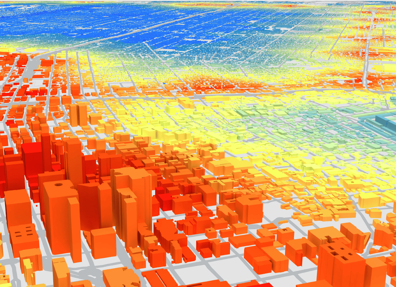
©maps.cga.harvard.edu
In this guide, we’ll unpack what urban analysis actually is, why it’s become non-negotiable for architects and city planners, and the ten core principles that show up in almost every serious urban study — the same ones we walk through in our own step-by-step site analysis guidelines for beginners if you want a more hands-on companion to this article.
In This Guide:
What Is Urban Analysis?
Urban analysis is the structured study of the social, demographic, and economic forces that shape a city, used to identify problems — like poor waste management, uneven access to healthcare, or unsafe streets — before a single building goes up. It sits at the foundation of urban planning precisely because it forces planners to separate the symptoms of a struggling neighborhood from their actual root causes.
The reason this matters goes well beyond any single project. Cities everywhere are under pressure to grow more sustainably, reduce inequality, and widen access to economic opportunity, and urban analysis is one of the few tools that turns those goals into something measurable. It’s also how researchers compare urbanization patterns across countries and pinpoint where vulnerable populations are concentrated, which in turn shapes where aid, infrastructure, and housing investment actually go.
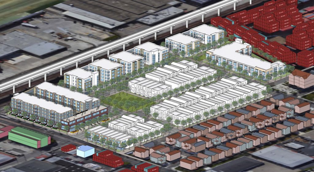
©maps.cga.harvard.edu
Why Urban Analysis Matters Right Now
Urban analysis matters more in 2026 than it did even five years ago because the pace of urbanization has outrun earlier forecasts. The UN’s 2025 World Urbanization Prospects report found that the share of people living in cities has more than doubled since 1950, and that the number of megacities — those with over 10 million residents — has quadrupled since 1975, jumping from eight to 33, with more than half of the new ones in Asia. Cities that once had decades to plan for growth now sometimes have only a few years.

That kind of pressure changes what “good design” even means. A tower, a park, or a transit line that isn’t grounded in an honest urban analysis risks solving yesterday’s problem instead of tomorrow’s. This is exactly why so much of the industry’s attention has shifted toward innovative sustainable design solutions that respond directly to the data a proper urban study uncovers, rather than to assumptions about what a neighborhood needs.
Understanding this context also explains why so many of the most talked-about buildings of the past few years — from adaptive reuse projects to the wave of net-zero skyscrapers reshaping dense downtowns — started with an unglamorous stack of population charts, transit maps, and utility surveys long before anyone sketched a facade.
The 10 Core Concepts of Urban Analysis
A thorough urban analysis takes careful observation, coordination with local stakeholders, and the right software — tools like Sketchup and CityCAD show up constantly in professional workflows. Here are the ten concepts that come up in nearly every serious study.
1. The History of the Site
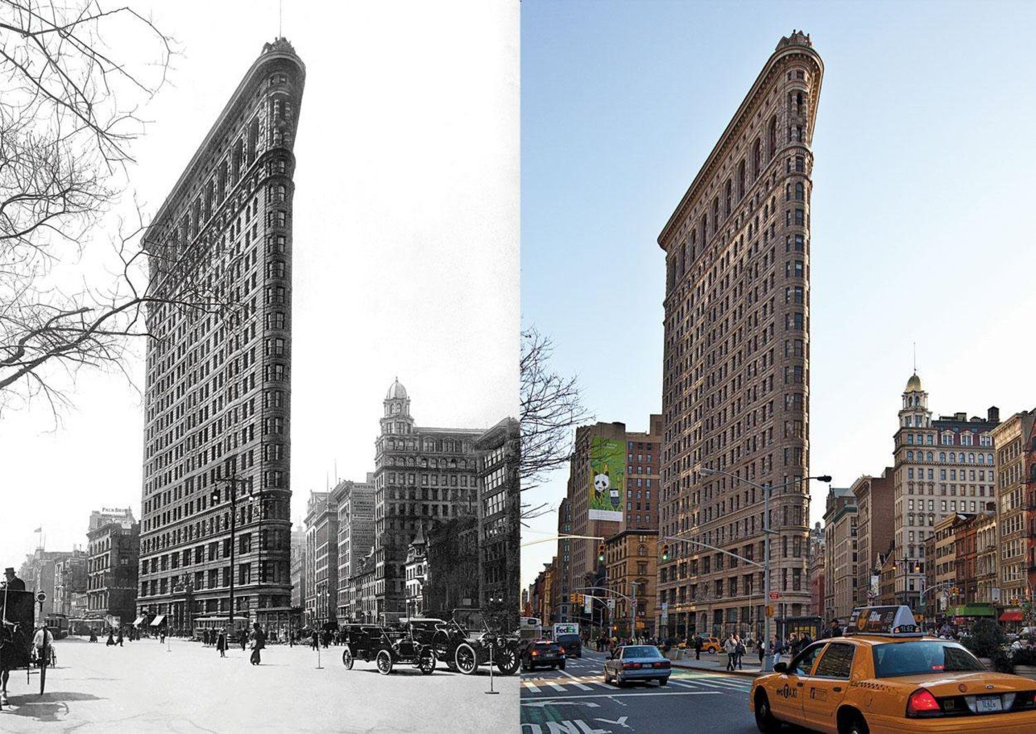
©viewing.nyc
Every urban analysis starts by understanding how a place got to be the way it is. That means learning how residents have historically moved through the area, how much time they spend outdoors, how the population has shifted, and what architectural styles came before. It’s less about nostalgia and more about grounding: a design rooted in real precedent tends to fit a place, while one built on guesswork usually doesn’t. History also flags which past interventions actually worked, which is often more useful than starting from a blank page.
2. Geographical Position and Its Implications

©rare-gallery.com
A city’s location dictates almost every environmental decision that follows it. Rainfall, wind direction and speed, humidity, topography, and the surrounding landscape all come from geography, and they determine how a site and any proposed intervention will actually perform once it’s built. Skipping this step is how projects end up flooding in a rainy season nobody planned for, or facing wind loads nobody modeled.
3. Economic Activity in the City

©en.astelus.com
What actually powers the local economy shapes everything else you design around it. Is the neighborhood built on produce markets, hospitality, manufacturing, or upscale retail? That answer determines how you plan water systems, green space, and transportation routes, since a market district and a business park place very different demands on infrastructure.
4. Layout and Construction Diagram
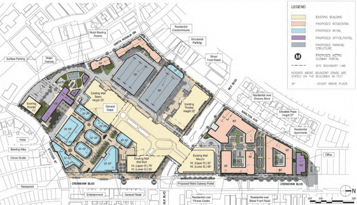
©keywordbaskets.com
A ground plan is one of the fastest ways to see a city’s actual density. It highlights built mass while leaving open areas blank, which makes it easy to read the constructed environment, greenery, road network, and how space gets used overall — often revealing imbalances that aren’t obvious from street level.
5. Transportation Accessibility
©needpix.com
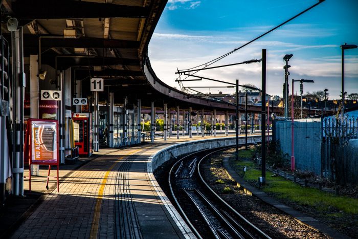
How easily people can reach a site changes almost everything about what belongs there. Before any intervention begins, it’s worth mapping out bus, rail, and other transit options into and out of the neighborhood, and checking that they’re actually affordable for the people who’d use them. Study current commuting habits closely, find where the gaps are, and design to close them rather than around them.
6. The City’s Population

©educationquizzes.com
Population data only becomes useful once you look at it across past, present, and future together. A city of 400,000 in 2018 that’s projected to hit 800,000 by 2026 needs infrastructure sized for the number it’s becoming, not the number it already is. This is exactly the kind of forecasting the UN’s own urbanization data is built around, and it’s why so many “surprise” infrastructure shortfalls trace back to outdated population assumptions.
7. Underground and Grade-Level Utilities
©Bolton & Menc, Inc.
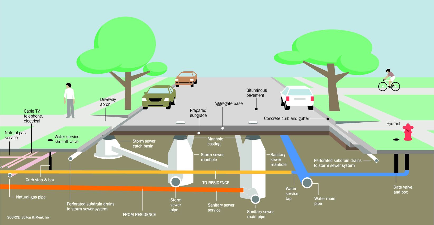
Knowing how sewage, water, and wastewater lines run beneath a site prevents some of the most expensive mistakes in urban development. It’s worth understanding whether wastewater is treated on-site or released into a nearby body of water, and where drinking water actually comes from — a local source, or one people have to travel for. At minimum, a site needs some form of primary waste treatment nearby, plus a clear plan for solid waste collection.
8. Aspects of Spatial Interaction
©abg-geosynthetics.com
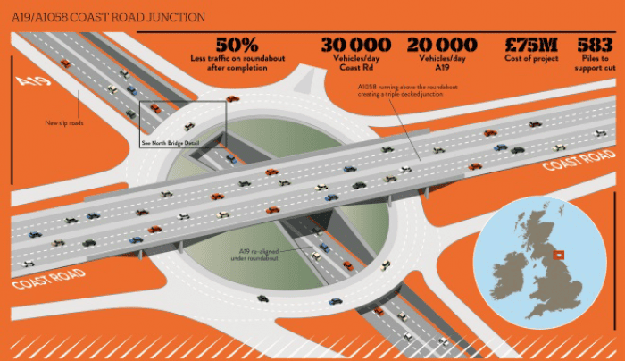
Spatial interaction describes how the different pieces of a city actually work together. The core question is whether existing roads, sidewalks, and connections between them meet a reasonable standard of usability — or whether people are constantly working around infrastructure that was never designed to talk to itself.
9. Existing Land Use
©masterplansindia.com
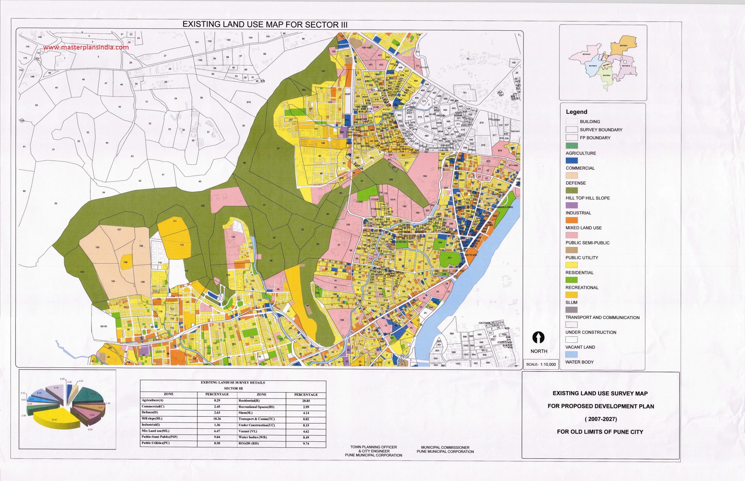
Looking at how a site or building is currently used tells you a lot about whether that use is actually sustainable. An existing land-use study uncovers what’s already happened on a site, what alternative uses might fit better, and whether the local planning commission has placed any restrictions worth knowing about before you get attached to a concept.
10. Greenery and Open Areas

©Tomáš Hustoles
Open space in a city is anything from a water fountain to a full public park, and studying how people actually use it reveals patterns no survey will capture. Watching who shows up on weekends, where parents gather with kids during the week, and how plant life responds to shade at different times of day all feeds directly into design decisions that are far more likely to succeed because they’re based on how the space is genuinely used, not how it was intended to be used on paper. This is also where a deeper sustainable landscape architecture strategy tends to start — not with a planting plan, but with an honest look at existing behavior in the space.
If you’re planning a city or a single site within one, this is the point where everything comes together: an urban analysis that genuinely considers liveability, aesthetics, and function, built a few years ahead of the population it’s designed for, with every relevant stakeholder pulled into the process early.
Site Analysis vs. Urban Analysis: What’s the Difference?
Site analysis studies one parcel of land in detail; urban analysis studies the entire city or district that parcel sits inside. The two overlap constantly, and in practice most projects need both — a building’s site analysis is really just urban analysis zoomed all the way in.
| Factor | Site Analysis | Urban Analysis |
|---|---|---|
| Scale | One parcel or building lot | Neighborhood, district, or whole city |
| Focus | Climate, access, legal context, immediate surroundings | Population trends, economics, infrastructure networks |
| Typical output | A site plan, issues/opportunities diagram | Growth projections, land-use maps, policy recommendations |
| Who uses it | Architects, individual project teams | Urban planners, municipalities, policymakers |
If you’re new to this process and want to work through it hands-on rather than in the abstract, our site analysis guidelines for beginners walk through the exact steps to take before a single line gets drawn.
What Software Do Planners Use for Urban Analysis?
Most urban analysts rely on a mix of GIS platforms, 3D modeling tools, and dedicated urban design software rather than any single program. GIS platforms handle the spatial and demographic layers — population density, zoning boundaries, flood risk — while tools like Sketchup and CityCAD help translate that data into massing studies and 3D context models planners can actually present to stakeholders. For anyone weighing which platform fits a specific project, our roundup of urban planning software and mapping tools compares the most widely used options in the field today.
When Should Urban Analysis Happen in a Project?
Urban analysis should happen before schematic design starts, not alongside it. Trying to run population, transit, and land-use studies at the same time you’re sketching massing options almost always means the design ends up shaping the analysis, instead of the other way around. The strongest projects treat urban analysis as its own distinct phase — usually weeks, sometimes longer for large districts — with a clear sign-off before any concept work begins. It’s also the stage where sustainability targets get baked in early, which is a big part of why so many recent sustainable buildings perform as well as they do: the groundwork was done long before the first render.
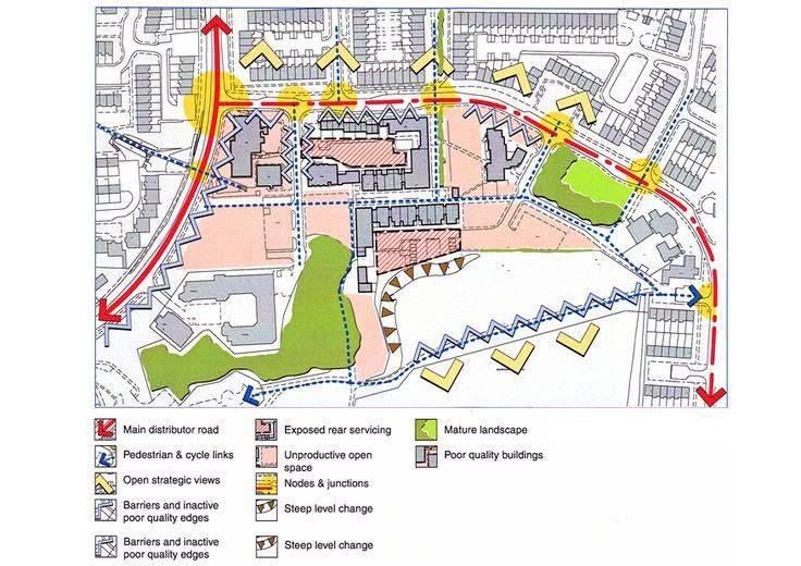
Urban analysis will never be the most glamorous part of a project, and it rarely makes it into a portfolio the way a striking facade does. But every genuinely good building, park, or transit line traces back to someone who did this unglamorous work first — reading the population data, walking the site at different hours, checking who actually shows up and when. Skip that step, and even the best-designed building is really just a good-looking guess.

Emily Reyes is a Brooklyn-based architecture writer and Article Curator at Arch2O, known for her sharp eye for experimental design and critical theory. A graduate of the Southern California Institute of Architecture (SCI-Arc), Emily’s early work explored speculative urbanism and the boundaries between digital form and physical space. After a few years in Los Angeles working with boutique studios on concept-driven installations, she pivoted toward editorial work, drawn by the need to contextualize and critique the fast-evolving architectural discourse. At Arch2O, she curates articles that dissect emerging technologies, post-anthropocentric design, and contemporary spatial politics. Emily also lectures occasionally and contributes essays to independent design journals across North America.