

Urban design is the design of the spaces between buildings: the pattern of streets and blocks, how buildings meet the street, and the public spaces where people walk, meet and stay. Good urban design rests on a few principles that recur in almost every authoritative guide: a connected network of streets, blocks small enough to walk around, buildings that face and enclose the street, a mix of uses, and public spaces designed for people rather than only for traffic. This guide is for architecture and planning students and early-career designers. It explains those principles, analyses three precedents (Barcelona’s Eixample, its superblocks and Copenhagen’s Strøget) and lists the guidance documents to cite, with their jurisdiction and date.
Quick answer: the principles that matter most
- Connected streets. A permeable network with many junctions gives walkers and cyclists short, direct routes and spreads traffic.
- Walkable blocks. Smaller blocks mean more corners, more route choices and more street frontage per hectare.
- Buildings that define the street. Continuous frontages with entrances and windows facing the street create enclosure and natural surveillance.
- Active ground floors and mixed uses. Shops, cafés, workshops and front doors at street level bring people and reasons to walk.
- Streets as places, not only routes. Street space is shared between movement and staying: pavements, trees, seating and slow traffic.
- Legible public spaces. Squares, parks and courtyards are placed where routes meet, sized for their use and overlooked by buildings.
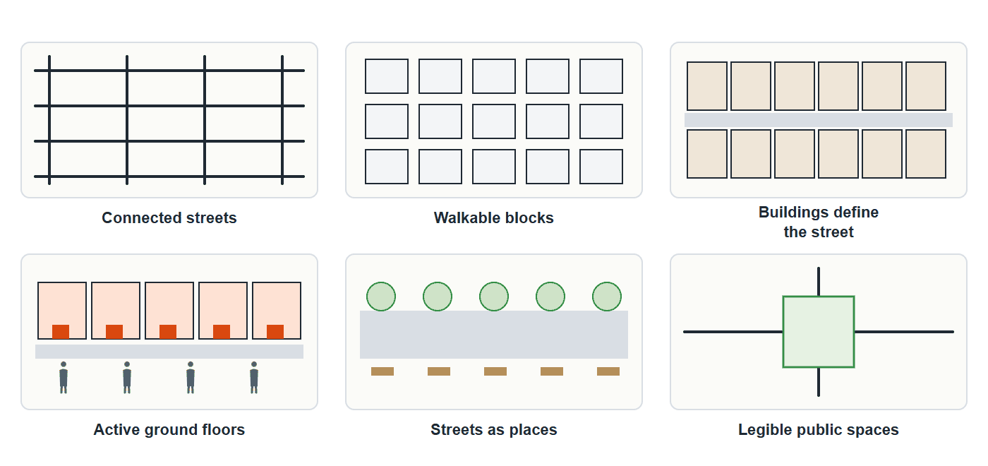
Six principles of good streets and neighbourhoods: connected streets, walkable blocks, buildings that define the street, active ground floors with mixed uses, streets as places as well as routes, and legible public spaces where routes meet. Diagram: Arch2O
Urban design principles explained
Streets and connectivity
The street network is the most permanent layer of a city: buildings are replaced, but street patterns often last for centuries. England’s National Design Guide (Ministry of Housing, Communities and Local Government, published 2019, updated January 2021) lists “movement” among its ten characteristics of well-designed places, alongside context, identity, built form, nature, public spaces, uses, homes and buildings, resources and lifespan. Its approach, like most current guidance, favours connected networks over cul-de-sac layouts because they make walking and cycling the easiest choice for short trips.
Blocks and plots
Block size controls how walkable an area is. Small blocks give more route choice and more corners, which are natural places for shops and meeting; very large blocks force long detours and tend to turn their backs on the street. Within each block, the plot pattern matters too: many narrow plots produce a varied street with many entrances, while one large plot often produces a single long, blank facade.
Built form and frontage
Buildings that line the street with their fronts, entrances and windows give it a sense of enclosure and make it feel safe, because people inside can see out. The ratio of building height to street width shapes how enclosed a street feels: too low and wide, and the space feels empty; too tall and narrow, and it can feel dark. Corner buildings deserve special attention, since they face two streets and are seen from further away.
Uses and the ground floor
Mixed uses spread activity across the day. The ground floor carries most of the weight: shopfronts, lobbies, workshops and front doors create interest at walking pace, while long blank walls, car-park entrances and service yards drain life from a street. Where ground-floor shops are not viable, front doors and front gardens of homes still keep a street active.
Streets as places
Streets are the largest public space in most cities. Guidance such as the UK Department for Transport’s Manual for Streets (2007, for residential streets in England and Wales) and the NACTO Urban Street Design Guide (2013, for US cities) treat streets as places for people as well as routes for vehicles, with design speeds, crossings and planting chosen to suit both. Small elements matter here too, from street trees to seating; Arch2O has covered examples such as parametric street furniture for Hong Kong.
Precedent analysis
Barcelona’s Eixample: a planned grid of chamfered blocks
Ildefons Cerdà’s 1859 plan for the extension (Eixample) of Barcelona laid out a grid of square blocks about 113 m (371 ft) on each side, with the corners cut at 45 degrees to form small octagonal squares at every junction. Cerdà intended buildings to occupy only part of each block, leaving gardens inside, and argued that the cut corners would improve air flow, visibility and the turning of trams, according to Failed Architecture. Over time the blocks were built up far more densely than he planned, and most interior gardens were filled in.
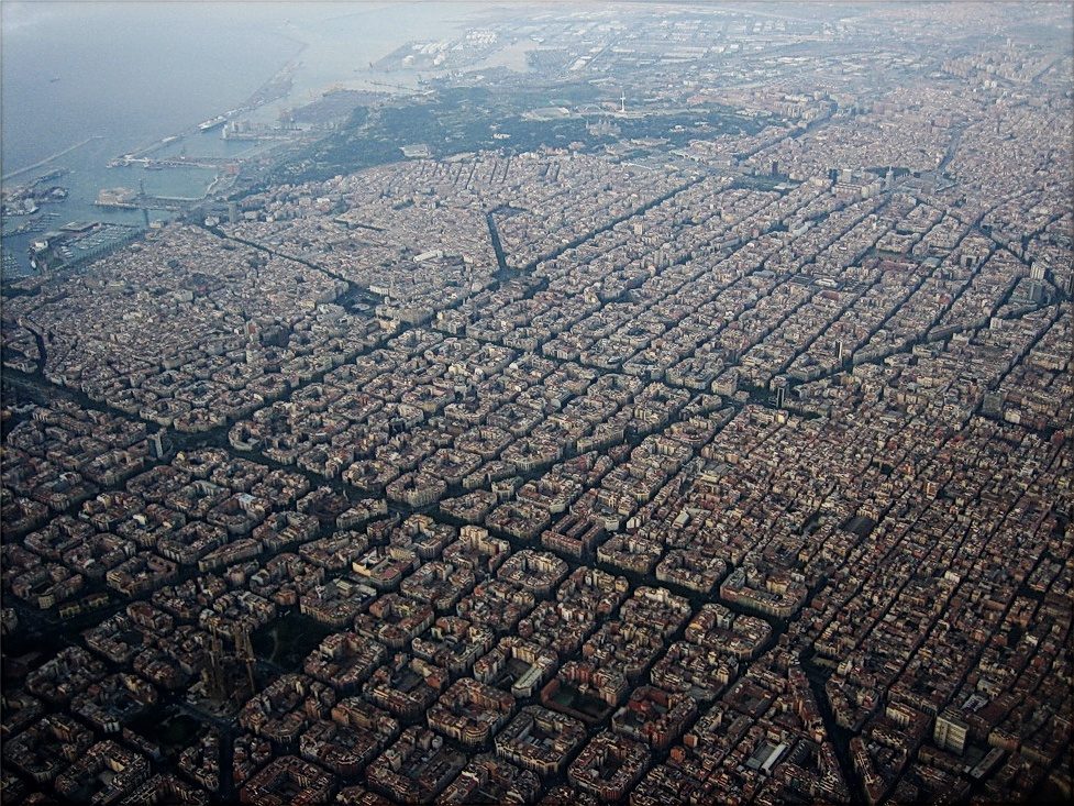
Barcelona's Eixample from the air: Cerdà's grid of chamfered blocks and the diagonal avenues. Photo: Alhzeiia, CC BY-SA 2.0, via Wikimedia Commons. Alhzeiia, source, CC BY-SA 2.0
The lesson for designers is that a strong, uniform street grid can absorb very different buildings over 150 years and still work, but that the open spaces inside blocks need protection, or they disappear.
Barcelona’s superblocks: taking back the street
From 2016 Barcelona began grouping several Eixample-style blocks into “superblocks” (superilles), where through-traffic is routed around the edge and the inner streets are given back to walking, play and planting. The first pilot started in Poblenou in September 2016, and the Sant Antoni superblock followed in 2018, according to Urban Land. The World Health Organization has described the programme as an example of using urban design to improve urban health.
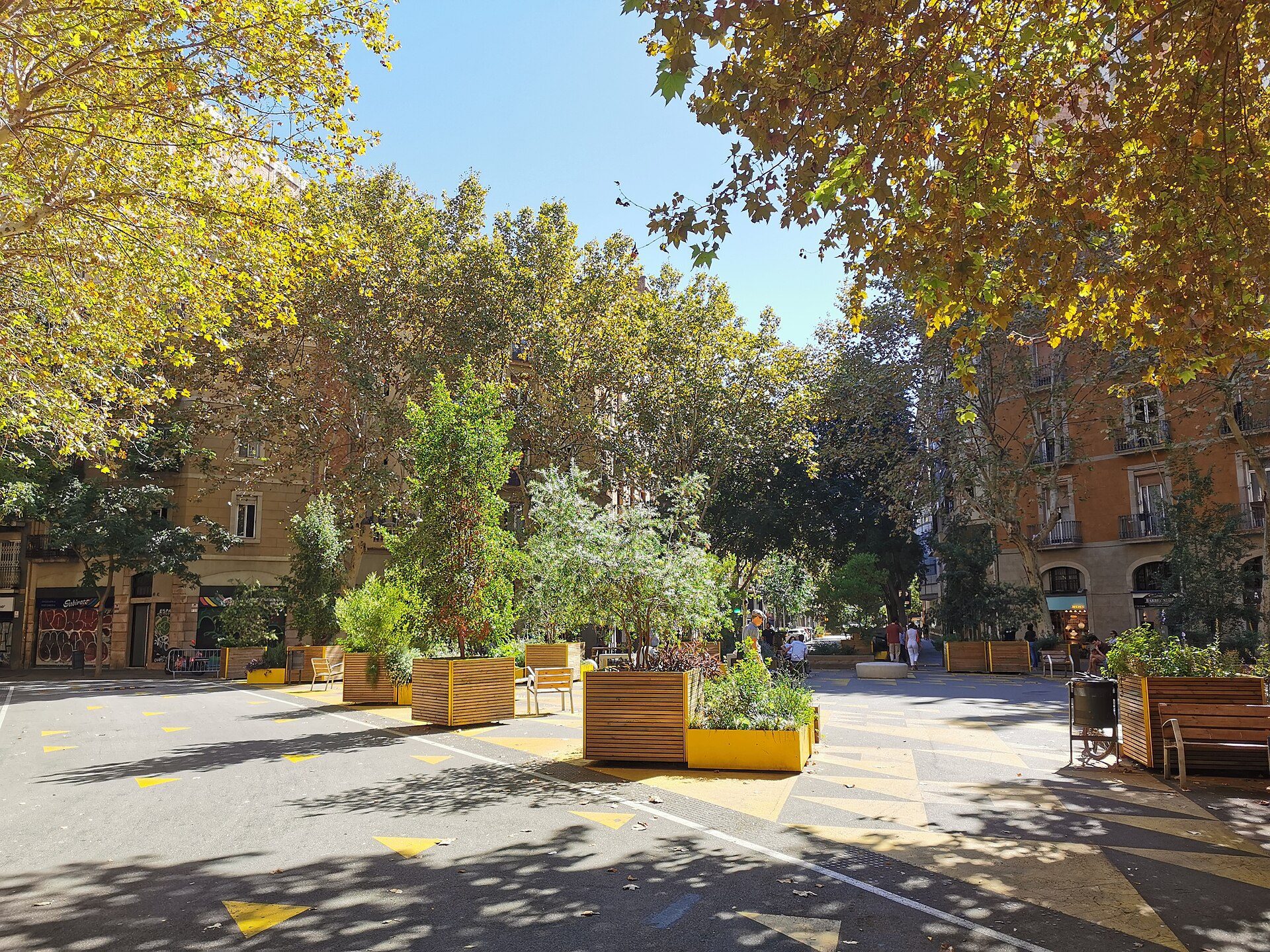
A former traffic junction in the Sant Antoni superblock, Barcelona, now with planters and seating. Photo: Cataleirxs, CC BY-SA 4.0, via Wikimedia Commons. Cataleirxs, source, CC BY-SA 4.0
The superblocks show that urban design can change an existing city without demolishing buildings: the grid stays, but the use of the street changes. Similar ideas have been tested elsewhere, such as the park block pilot in Los Angeles.
Copenhagen’s Strøget: pedestrian streets and public life
Copenhagen closed Strøget, its main shopping street, to cars in 1962. The architect Jan Gehl and colleagues at the Royal Danish Academy then studied how people used the city centre’s streets and squares over the following decades, published as Public Space, Public Life (1996) with Lars Gemzøe, as recorded by the Transportation Research Board. Their method of counting pedestrians and observing where people stop and sit has since been used by many cities to test whether public space works.
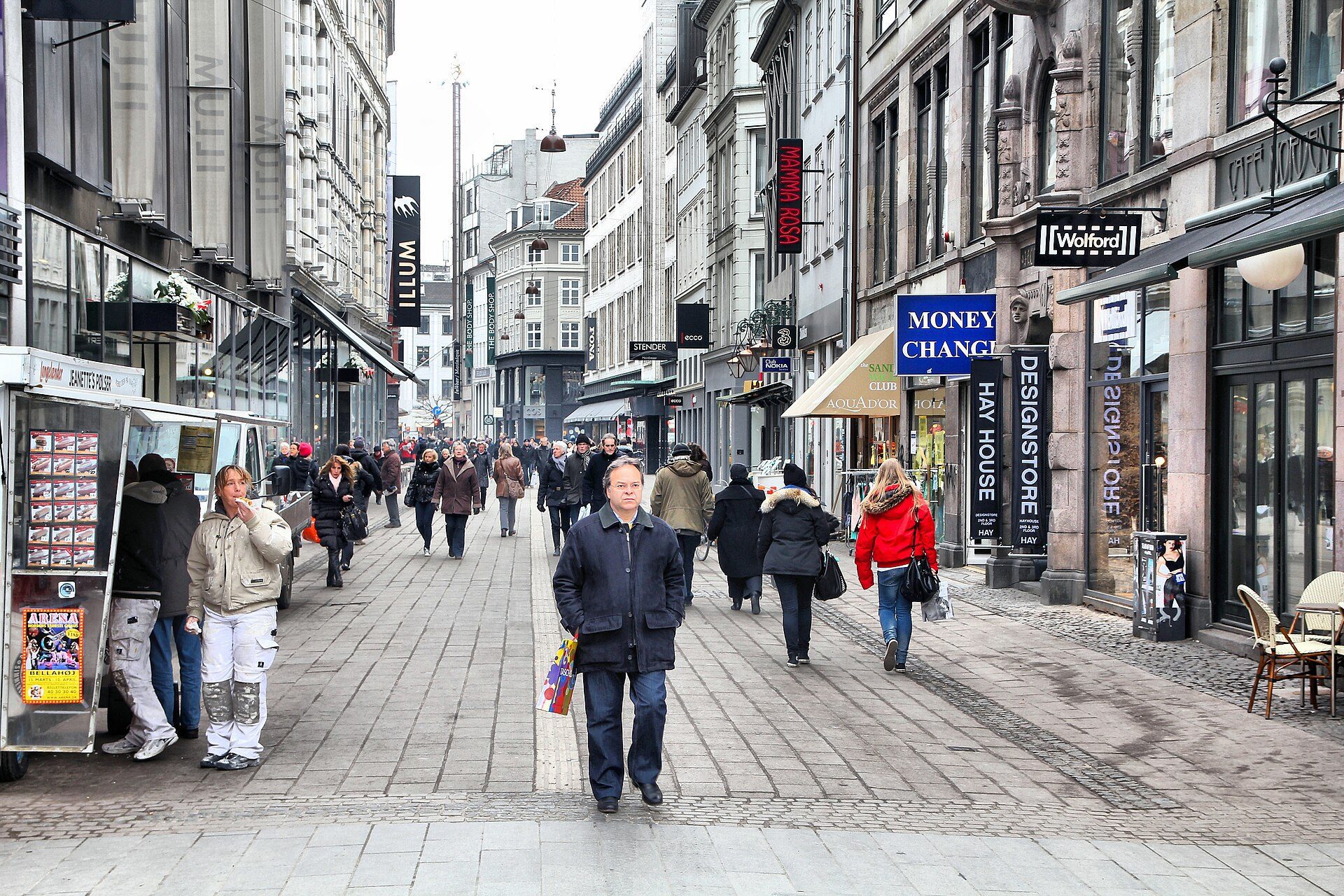
Østergade, part of Strøget, Copenhagen's pedestrian street since 1962. Photo: Marek Ślusarczyk, CC BY 3.0, via Wikimedia Commons. Marek Ślusarczyk (Tupungato) Photo portfolio, source, CC BY 3.0
The lesson is to measure public life, not only traffic: counting how many people walk, stand and sit in a space before and after a change gives evidence for design decisions.
Standards and guidance to check
| Document | Publisher | Jurisdiction | Edition | Use |
|---|---|---|---|---|
| National Design Guide | MHCLG (UK Government) | England | 2019, updated Jan 2021 | Ten characteristics of well-designed places |
| Manual for Streets | Department for Transport | England and Wales | 2007 (Manual for Streets 2, CIHT, 2010) | Residential and lightly trafficked streets |
| Urban Street Design Guide | NACTO | United States (city streets) | 2013 | Street design, crossings, design speed |
| Global Street Design Guide | Global Designing Cities Initiative / NACTO | International | 2016 | Street design across contexts |
Source: Publishers' pages (accessed 30 Oct 2026) (as of 30 October 2026).
These documents are guidance, not universal rules. Local plans, highway standards and design codes govern what can be built in each place, and figures from one country (for example lane widths or design speeds) should not be applied elsewhere without checking local requirements.
Checklist for students and designers
- Draw the street network first, at a scale that shows how the site connects to its surroundings.
- Test block sizes by walking distances: can people reach the nearest shop, stop or park directly?
- Draw building fronts and backs: every street should be faced by fronts and entrances.
- Mark ground-floor uses on plan and look for blank frontages.
- Draw at least one street section showing building heights, pavement, carriageway and trees.
- Place public spaces where routes meet, and check they are overlooked.
- Name the guidance you used, its jurisdiction and edition, and note where local rules differ.
In short, urban design starts with streets and blocks and is judged by how people use the spaces between buildings. Study the Eixample for its grid, the superblocks for how to adapt it, and Strøget for how to measure public life, then test your own scheme against the checklist above.

Luca Moretti is a content strategist with a foundation in urban design and architecture. Based in Milan, he focuses on writing that bridges aesthetics, material culture, and everyday spatial experiences.